
How Emeryville is Preparing for Rising Seas
EMERYVILLE, Calif. — Along the edge of the San Francisco Bay, Emeryville’s shoreline tells the story of a city built around the water. Apartment towers rise near the coast. The Bay Trail traces the shoreline. Interstate 80 and the eastern approach to the Bay Bridge carry thousands of travelers past the city every day.
But the water that helped make this city valuable is slowly rising, threatening a community where decades of investment in housing, businesses, transit, parks and infrastructure make simply abandoning vulnerable areas unrealistic.
"Heavy investment in transit nearby and commercial and residential towers make retreat financially and politically untenable,” said Amber Evans of Emeryville's Community Development Department.
That leaves Emeryville with a difficult local government challenge: how does the city protect the community it has already built while preparing for climate conditions only a couple decades into the future?
Why Emeryville Has to Act Now
Emeryville only spans roughly 1.2 square miles — the size of New York City’s Central Park — leaving little room for a densely developed downtown to move away from its shoreline.
According to the State of California Sea Level Rise Guidance, Emeryville & the San Francisco Shoreline are expected to rise nearly 9.6 inches by 2050. By 2100, sea levels are predicted to reach up to 3.1 feet with extreme risk scenarios up to 6.6 feet or higher.
Emeryville is already experiencing flooding and erratic weather which rising seas are expected to worsen.
Recent king tides in Emeryville have reached approximately 7 feet, which turned low-lying marina parking lots, local paths and coastal spots into shallow water, an eerie foreshadow.
As average sea levels rise, tides and storms begin from a higher baseline, allowing water to reach farther inland, making flooding more frequent.
Evans said Emeryville’s low elevation, combined with the already common flooding during storms and king tides, offers a warning of how rising seas could worsen inundation in the future.
But the threat doesn’t stop at the shoreline. Sea-level rise can also push groundwater higher beneath coastal communities, creating risks beyond areas directly exposed to shoreline flooding. Rising groundwater has the potential to flood building foundations from the bottom up, damage underground sewer and utility pipes and mobilize harmful contaminants left in soil from Emeryville’s industrial past.
Evans said rising groundwater could make the impacts of sea-level rise more widespread, with risks potentially extending to areas well inland from the shore.
Planning Before the Flooding Gets Worse
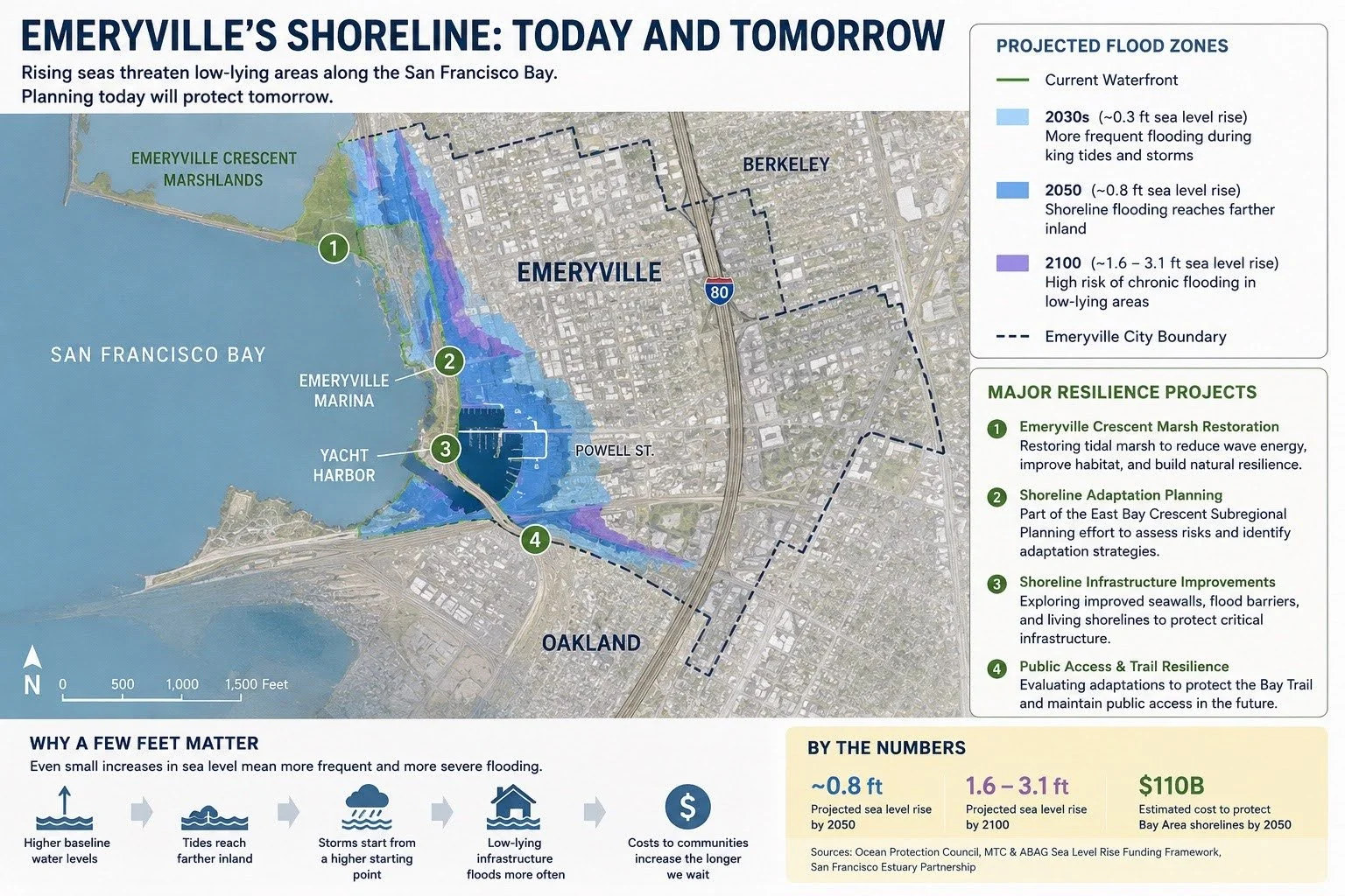
Projected sea-level rise could increase flooding along Emeryville’s low-lying shoreline, threatening infrastructure, public spaces and natural habitat as the city develops long-term adaptation strategies. (Infographic by Avery Ehrig)
For Emeryville, preparing for rising seas begins long before water reaches homes, businesses or critical infrastructure. Rather than waiting for flooding to become a regular emergency, the city is working with regional partners to identify where it is most vulnerable and determine how future development and infrastructure can adapt.
In 2025, Emeryville began working with the San Francisco Estuary Partnership and neighboring East Bay communities on a subregional shoreline adaptation plan. The process will assess vulnerabilities along the shoreline and identify strategies to protect residents, infrastructure and natural areas as sea levels rise.
The work comes as California is requiring communities along San Francisco Bay to plan ahead. Under Senate Bill 272, Bay shoreline officials must develop sea-level rise adaptation plans by 2034. For Emeryville, however, the process is more than meeting a state requirement. Findings from the vulnerability assessment are expected to inform the city’s General Plan update, meaning the risks identified today could influence future decisions about development, infrastructure and land use.
The planning process is evaluating adaption strategies ranging from marsh restoration and other nature-based shoreline protections to upgraded pump stations, improved drainage systems and elevated infrastructure in flood-prone areas.
But turning those plans into protection comes with one critical obstacle: money.
"The costs of adaptation, whether nature based or grey/green investments to protect existing residents, habitats and infrastructure is high and of regional significance,” said Evans.
Someone ultimately has to pay. Requiring developers to contribute can increase development costs. Putting more of the burden on existing residents can worsen affordability. Yet delaying adaptation could leave the region with far larger costs.
Funding for sea-level rise adaptation is spread across local, regional, state and federal governments, along with private property owners. Protecting the San Francisco Bay shoreline is estimated to cost roughly $100 billion by 2050, while only about $5 billion is currently dedicated, according to the MTC and ABAG Sea Level Rise Funding Framework.
Without sufficient investment, regional flooding damages from flooding and storm surges could ultimately exceed $230 billion.
Building Resilience Before Disaster
Sea-level rise planning sounds like it’s meant for 2100. But decisions being made now could determine where future housing is built, how infrastructure withstands flooding and which public spaces receive protection.
"Preparing now for where storm and king tide block seasonal access or create high operational costs or damage will save dollars in the future,” Evans said.
For Emeryville, preparing for rising seas isn’t simply about protecting its shoreline. It’s about ensuring the community built beside it can continue to function as the Bay rises.
*Cover Image Courtesy of https://www.coastal.ca.gov/kingtides/